In summary:
- Advances in remote sensing, cloud-based software, AI and machine learning have made GIS more affordable and accessible than at any time in in its history
- Laser-based light detection and ranging (Lidar) technology, which can accurately identify plant species and record biomass, is now cheap and compact enough to apply to drones
- As a leader in geospatial data analysis, AI, and environmental law, the UK is setting the bar for global developments in biodiversity monitoring and improvement
- Esri, the world’s largest GIS software company and one of the largest privately held software companies in the world, has a 40% share of the global GIS market
- Esri UK services, including ArcGIS, are used by two-thirds of local authorities in England and Wales and consultancies Arcadis, Arup, Atkins Rèalis, Jacobs, LUC, Mott MacDonald, RSK Group, Skansksa, SLR, Stantec, Sweco, Temple, Tetra Tech and WSP.
The practice of ecology may conjure up images of pond dipping and butterfly nets, but it has become an extremely high-tech occupation. Consequently, entering the London office of Canadian-headquartered global consultancy AtkinsRéalis more than a year ago felt like walking into NASA’s mission control centre.
The building’s ‘Lava Lab’ tech hub is home to geospatial, machine learning and AI specialists, data scientists, strategists and visualisers, and enables 360° project visualisations, digital twin demonstrations and interactive meetings. The facilities are indicative of a paradigm shift in environmental consultancy in which data entry and number crunching has been taken over by algorithms, leaving humans with more interesting, productive and proactive roles.
Consulting in the age of data
It’s hard to over-estimate the significance for environmental consulting of the availability of near-real-time streams of critical data provided through enhanced remote sensing technology. Geospatial data can be captured from aerial observation or satellites, using high-resolution cameras, multispectral and thermal sensors, or laser-based light detection and ranging (Lidar).
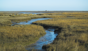
Improvements in satellite technology mean that it can now provide very high resolution images, previously only available from aerial surveillance. Lidar technology, which is light and affordable enough to be used in drones, can penetrate clouds. It can accurately measure canopy heights and biomass area as well as soil types and the wildlife movements of habitats. Such advances mean that GIS — also termed location intelligence or spatial analytics — has transformed into an incredibly powerful tool.
The UK is a leader in geospatial data analysis and AI. It is also a pioneer in mandating environmental improvement by law. Following the Environment Act of 2021, biodiversity net gain (BNG) of at least 10% is now a legal requirement for all large new developments. Together, these facts mean that what happens in the UK has wider significance.
Global standard for GIS
A number of UK consulting firms are leading the way in the use of geospatial data for environmental benefits — and one thing many of them have in common is collaboration with the world’s largest GIS software company, San Francisco-based Esri. Founded in 1969, Esri brings in revenues of around $1.3bn and serves 650,000 organisations. The company now has a 40% share of the global GIS market.
Esri UK’s clients include the Met Office, the Environment Agency, Natural England and Defra, two-thirds of English and Welsh local authorities, the National Trust and the RSPB. It provides software and services to Arcadis, Arup, AtkinsRèalis, Jacobs, LUC, Mott MacDonald, RSK Group, Skanska, SLR Consulting, Stantec, Sweco, Temple, Tetra Tech and WSP.
Esri UK is providing increased GIS capacity to RSK via a three-year contract spanning 14 countries, which will allow RSK to deploy geospatial technology more easily and covers environmental impact and biodiversity net gain surveys for the water, renewable energy, property and construction industries.
It has also played a part in a solution created by AtkinsRèalis to streamline the processes involved in biodiversity net gain management. The solution includes a spatial common data environment, combining open source with FME, Esri UK’s ArcGIS Portal and Microsoft Azure.
Beyond biodiversity by numbers
Temple, a privately owned B Corp consultancy with a strong focus on ecology, has joined the Esri UK partner network. It has used Esri’s ArcGIS software to create the UKHab and BNG Survey Apps, to use for its own projects and to offer commercially.
However, Luke Chittock, Temple’s director of digital delivery, warns: "Remote sensing gives you an indicative representation of habitats but not an understanding of the full complexity of local conditions. It shouldn’t be used alone. If you just rely on remote sensing, without local understanding, there’s a danger that you’ll lose distinctive habitats and provide a generic outcome.BNG shouldn’t just be about generating biodiversity credits, it is about planning for biodiversity outcomes.
Interest in UK legislation is having a global impact. Australia and New Zealand are considering implementing BNG-based laws. Chittock says: "BNG will need to evolve. You could call it biodiversity by numbers. It’s probably going to be a precursor to a broader natural capital approach, looking at all the inputs needed to create habitat quality, such as water quality and soil health, factoring in food production and fluid and dynamic landscapes. However, it’s a good start."